welcome to
NORTHCOVE VISUALS
& "Their Story' 501(c)(3) Non-Profit
Professional Drone & Cinematic Solutions
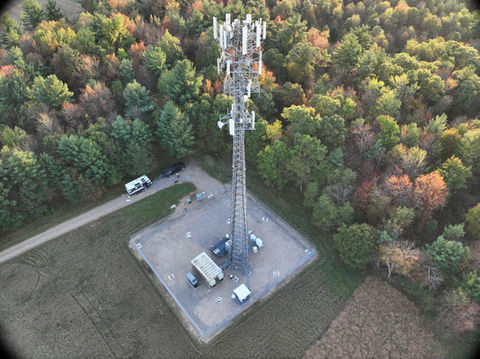
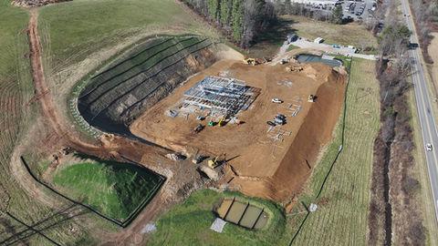
☑️ Residential, Commercial, Industrial Inspections
☑️ 3D Maps of Any Structures or Property
☑️ Cinematography
☑️ One-Shot Drone Fly Throughs
☑️ Ground & Aerial Still Photography
☑️ Film/Media Production & Editing
☑️ Advertisement Creation
☑️ Promotion on Facebook
❇️ Google Affiliated:
➡️ Street View "Blue Line" Updates
➡️ Business Photos & 360˚ Photos
➡️ Google 360˚ Tours
Located in the High Country of Western NC
Servicing the United States
*Featured in NY Times

Unique Experiences
Elevate your brand with our innovative drone services,
creating captivating and immersive experiences for your audience.
Let us take you to new heights.
Creative Concepts
Our team of experts will develop cutting-edge concepts tailored to your brand, ensuring each experience is unforgettable and leaves a lasting impression.
Engaging Activations
Drive consumer engagement with our interactive activations that bring your brand to life. From pop-up events to social media campaigns, we've got you covered.
Strategic Partnerships
Collaborate with NorthCove Visuals to forge strategic partnerships that amplify your brand's reach and impact. Let's work together to create magic.
Rebuilding Homes
Family #1
Mitchell County
*Seeking a new manufactured home*
Currently Seeking:
*spare vehicles
*manufactured homes
*home building supplies
*heavy machinery & operators
*junk dirt, rocks, gravel
*tree removal

Hire Professional Drone Pilots
-
Schedule a convenient time for our FAA-certified Part 107 drone pilots to visit your location.
-
Our team will deploy our advanced unmanned aircraft systems to capture high-resolution imagery and data.
-
We will compile a detailed report and deliver it directly to your desk or mobile device, ensuring you receive comprehensive insights promptly and efficiently.
Overall Project Efficiency Utilizing Drones
Construction and Infrastructure
Surveying and Mapping:
Drones can reduce surveying costs by up to 50%.
For example, a survey that costs $5,000 using traditional methods might cost $2,500 with drones.
Site Inspections:
Using drones can cut inspection costs by approximately 40%.
If traditional inspections cost $10,000, drones might reduce this to around $6,000.
Overall Efficiency:
According to a McKinsey report, drones can lead to overall cost reductions of up to 10% due to improved efficiency and reduced labor costs.
Agriculture
Crop Monitoring:
Drones can save up to 90% in time compared to manual crop scouting.
For instance, if manual scouting costs $20,000 per season, drones might reduce this to $2,000 to $4,000.
Precision Agriculture:
Drones can improve yield and reduce input costs by up to 20%, leading to significant savings depending on the scale of the operation. For a farm generating $500,000 in revenue, this could mean savings of $100,000.
Insurance
Claim Assessments:
Drones can reduce the time for property inspections by up to 50%, leading to faster claim processing and lower administrative costs. If claim assessments cost $15,000, drones might cut this to $7,500.
Fraud Detection:
Improved accuracy in assessments can help prevent fraudulent claims, potentially saving thousands of dollars annually.
Real Estate
Marketing Costs:
Using drones for property photography can reduce the cost of hiring cranes or helicopters, which can be thousands of dollars. Drones often provide a cost-effective solution, potentially saving up to 60% on aerial imagery costs.
Sales and Leasing:
Enhanced property visuals can lead to faster sales or leases, increasing revenue.
Drones can help close deals 20% faster, which could translate into significant financial gains depending on the property value.
Emergency Services
Search and Rescue:
Drones can speed up search efforts by up to 10 times compared to traditional methods, potentially reducing the costs of prolonged operations and resource deployment.
Disaster Response:
Rapid assessment and monitoring can lower operational costs during disasters by up to 30%, depending on the scale of the response and resources required.
General Operational Costs
Maintenance and Inspections:
Drones can reduce maintenance inspection costs by up to 70%. For a large facility where inspections might cost $50,000 annually, drones could cut this to $15,000.
Subscribe to our newsletter from NorthCove Visuals.


